
Drive the anticlockwise loop from Minehead through Lynton, Ilfracombe and Croyde, then back across Exmoor to Dulverton — 7 days, no retracing, all on roads worth driving.
If your ideal road trip involves narrow lanes that drop without warning to sea level, cliff-top villages connected by Victorian engineering, surf beaches backed by sand dunes, and moorland roads where the only traffic is a herd of Exmoor ponies, then this Exmoor road trip itinerary was made for you.
This 7-day loop starts and finishes in Minehead on the Somerset coast, running anticlockwise through Lynton and Lynmouth, along the North Devon coast through Ilfracombe and Croyde, inland to Barnstaple, then back east across the heart of Exmoor via Dulverton. No retracing. No motorways. Short legs with long rewards.
Minehead is a Victorian resort with a working harbour, a long sandy beach and North Hill rising steeply behind the seafront to the first proper piece of Exmoor. It makes a good first night: not dramatic enough to feel wasted, but interesting enough to stretch the legs after the journey down.
Walk the promenade from the harbour to the beach. Then climb North Hill on the footpath from the town centre: the view from the beacon at the top takes in the whole sweep of the Bristol Channel and the Welsh coast on the horizon. Back in town, the station at the bottom of the High Street is the eastern terminus of the West Somerset Railway, a 20-mile preserved steam line through the Quantock foothills. It runs most days in summer and the journey to Bishops Lydeard and back takes about 90 minutes.

The 25-mile drive west from Minehead on the A39 is the first proper test of the route. The road climbs over Porlock Hill, at up to 25% gradient one of the steepest A-roads in England, before crossing the edge of Exmoor above the Bristol Channel. The views between the hedgerows are worth the slow pace. If you are in a loaded campervan or simply prefer not to tackle a 1-in-4 descent, the Toll Road bypasses Porlock Hill for a small charge.
Lynton and Lynmouth are two villages occupying completely different altitudes. Lynmouth sits in the East Lyn gorge at sea level, a pretty harbour village with pubs and restaurants. Lynton stands 153 metres above it on the clifftop, reached by the Cliff Railway, a water-powered funicular built in 1890 and still running on the same principle: fill the upper car's tank with water from the stream, empty the lower car's tank, and gravity does the rest. Ride it at least once in each direction.
White chalk cliffs, a Norman conquest battlefield, cobblestoned medieval streets and a seaside city that refuses to be ordinary: this East Sussex road trip itinerary covers it all in seven days.
From Lynton, the walk west to the Valley of the Rocks takes under 30 minutes and should not be skipped. The valley is dry and open, with no trees, just great masses of weathered rock rising from the clifftop, wild goats picking their way across the faces and the sea a long way below. The main viewpoint looking down the coast is one of the best on the entire route.
Use your second day here for the riverside walk to Watersmeet through the East Lyn gorge (National Trust), or drive the inland lanes to Simonsbath and the open centre of Exmoor.
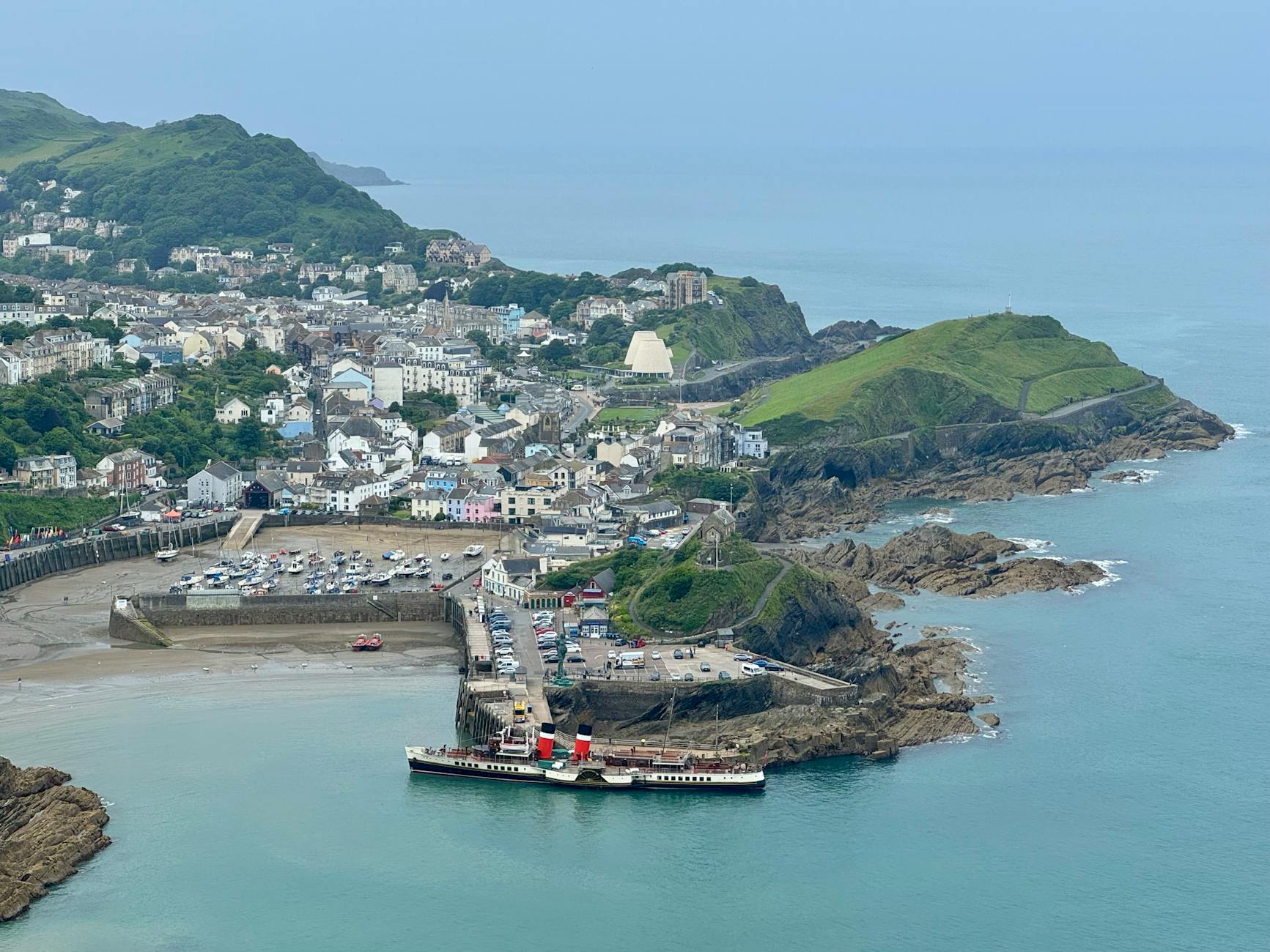
Ilfracombe is 15 miles west from Lynmouth and North Devon's largest resort, though that description gives no hint of what waits at the harbour entrance: Damien Hirst's 20-metre bronze sculpture Verity, holding aloft a sword, her internal anatomy exposed on one side. However you feel about it, it is not boring.
The town's best feature after the harbour is Tunnels Beaches, Victorian sea pools carved directly into the cliff and reached through hand-cut tunnels. They open on a tidal schedule, charge a modest admission, and are far better than the town beach. The harbour restaurants are good value for local crab and fish.
If the forecast is clear and you can book ahead, the ferry to Lundy Island is the standout excursion from Ilfracombe. The crossing takes two hours and the island has Atlantic puffins in spring and early summer, grey seals year-round, a pub, a lighthouse and very little else. It is exactly as remote as it sounds.
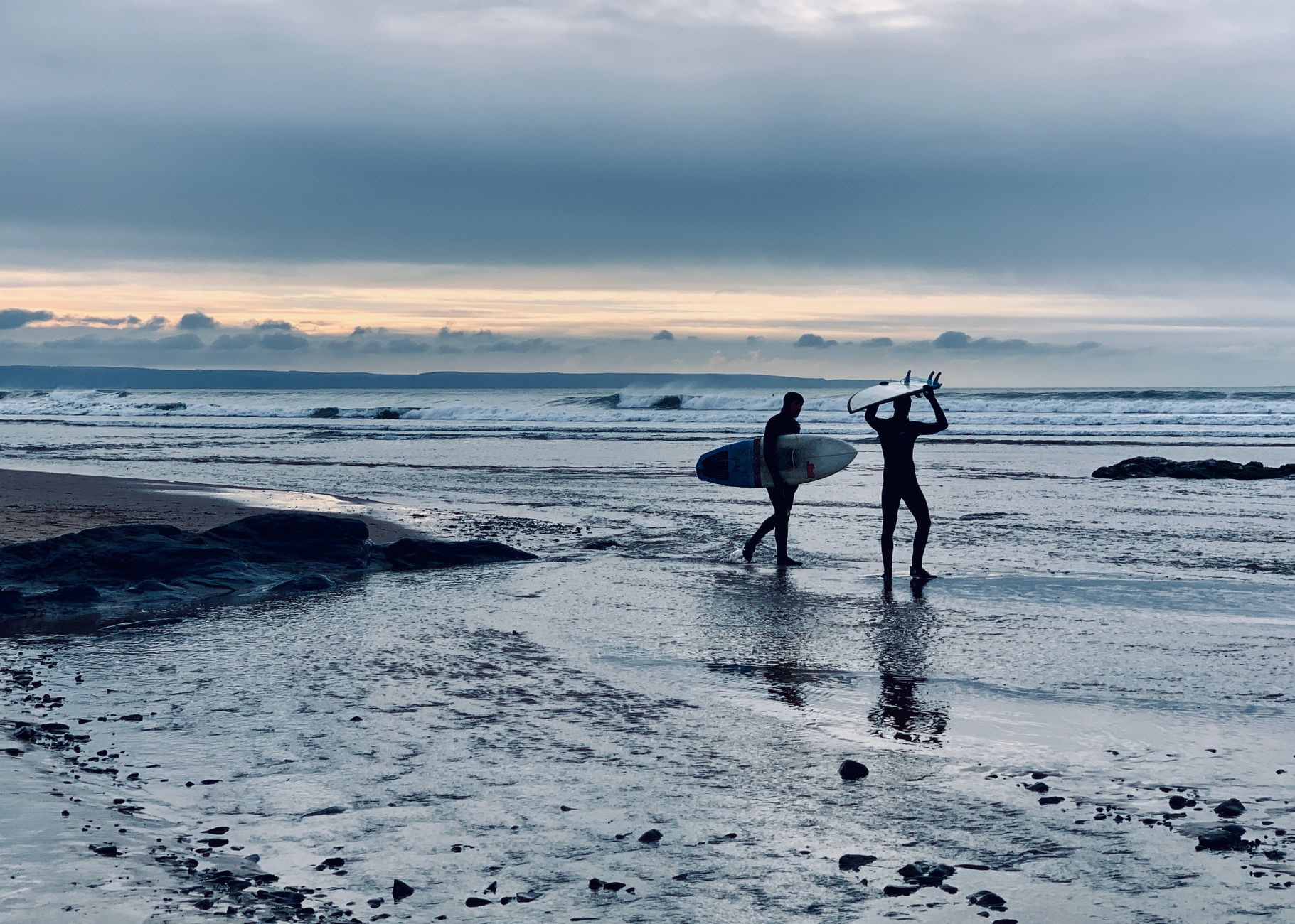
Croyde is 10 miles south of Ilfracombe, and the shift in atmosphere is marked. Where Ilfracombe feels like a resort, Croyde feels like a village that happens to have a world-class surf beach. The Atlantic swell arrives consistently, the waves are suitable for beginners and advanced surfers alike, and the equipment hire shops are well-stocked and competitively priced.
If surfing is not your thing, the Baggy Point walk is the best alternative on this stretch of coast. From the village, the footpath runs 1.5 miles to the tip of the headland, where grey seals haul out on the rocks below and Lundy Island is visible on clear days to the north-west. The return walk along the same path takes about 90 minutes in total.
Eat early in Croyde. The village has a handful of pubs and restaurants, all popular, and waiting lists build quickly from about 7pm in summer.
Barnstaple is 11 miles inland from Croyde and the practical centre of North Devon. It is not a scenic highlight of the route, but it is useful and genuinely more interesting than a transit stop. The Victorian Pannier Market, one of the largest covered markets in the South West, fills its great iron hall on Tuesday, Friday and Saturday mornings with local produce, crafts and second-hand books.
Barnstaple is also the starting point for the Tarka Trail, a 30-mile traffic-free path running along the Taw and Torridge estuaries to Bideford and beyond. Bike hire is available near Long Bridge, and even a short 5-mile out-and-back stretch along the river is worth an hour before the afternoon drive to Dulverton.

The drive from Barnstaple to Dulverton is the most rewarding of the week: 22 miles east on the A361 then south into the wooded Barle Valley. Dulverton is a small town with a National Park visitor centre, good independent shops, and pubs that take their food seriously.
The main excursion is Tarr Steps, 4 miles north on a narrow lane. The clapper bridge spans the River Barle in 17 stone slabs and is believed to be prehistoric, making it certainly one of the oldest bridges in Britain. Set in ancient oak woodland with the river running clear and brown below, it is one of those places that rewards the effort to get there. Drive up, park, and walk the riverside path for 30 minutes in either direction; you can also walk from Dulverton itself in about 3 hours return.
The final drive back to Minehead from Dulverton takes about 45 minutes on B-roads crossing the eastern plateau of Exmoor. Keep to the B3223 and B3224 through Exford and Wheddon Cross rather than following satnav down the unclassified lanes. Arriving from above the town on the descent into Minehead, with the Bristol Channel spread below, is a satisfying close to the loop.
May to September covers the main season when all attractions are running and the roads are clear. May and June are the sweet spot: the hedgerows are full, the light is good, visitor numbers are lower than in school holidays, and accommodation is easier to book. July and August bring higher prices and competition for parking at popular spots like Tarr Steps and Croyde. September has excellent light and the start of autumn colour on the moor.
Winter driving on Exmoor is feasible but some narrow moorland lanes can be icy or briefly impassable after heavy frost. The A39 coastal road stays open year-round; the B-roads over the high moor are the ones to treat with caution in cold spells.
Minehead is 3.5 hours from London by car via the M4 and M5, turning off at Bridgwater or Taunton. The West Somerset Railway has a station in Minehead if you want to arrive by train (change at Taunton on the Great Western mainline). Once on the loop, a car is essential: public transport between stops is limited, and the best roads are specifically the ones that the buses do not use.
Fuel: Fill up in Minehead, Ilfracombe or Barnstaple before heading into the smaller villages. Rural stations are rare and sometimes cash-only.
Roads: The A39 coastal road involves narrow sections with passing places. Drive slowly, pull over generously, and do not try to maintain a schedule on the winding stretches.
Wildlife: Exmoor ponies, red deer and sheep wander onto moorland roads, especially at dusk and dawn. Slow down on the open moor sections between Dulverton and Minehead.
Porlock Hill: The main A39 route over Porlock Hill has a maximum gradient of 1-in-4. Heavy campervans and trailers should use the Toll Road, which adds about 2 miles but cuts the gradient significantly and is well signposted from the A39 at Porlock.
Accommodation: The route has a good spread of B&Bs, pub rooms and small hotels at each stop. Book ahead in July and August, particularly at Lynton/Lynmouth and Croyde which have limited capacity.
An 8-day Northern Arizona road trip looping from Phoenix through Jerome, Sedona, Flagstaff, the Grand Canyon South Rim and Route 66 Williams. Full itinerary with drives, stops and the best time to go.
The full route — stops, maps, and driving times — is on Routebook by Kington.
A 7-day anticlockwise loop from Minehead through Exmoor's cliff-top villages, North Devon's surf beaches and moorland backroads, returning through the heart of the national park.
 Routebookby Routebook
